When AI Meets 100,000 Geologists: Turning Hidden Clues into Mineral Targets

Recap from Part 1: Turning Geochemical Anomalies into Exploration Leads
In Part 1, we explored a high-resolution geochemical workflow using Saudi Arabia’s GCAS stream sediment dataset to extract mineral exploration insights. This dataset, which includes trace elements such as gold (Au), copper (Cu), and arsenic (As) from tens of thousands of samples, underwent a structured, multi-stage analysis to identify meaningful patterns in the data.
 Russell Menezes
First, we performed rigorous data preprocessing—resolving detection limits and standardizing metadata across the dataset. This ensured consistency for downstream analysis. Next, we applied a two-pronged outlier detection strategy: univariate methods using interquartile range (IQR) and multivariate techniques using Isolation Forests. The latter proved especially effective in capturing subtle, multi-element geochemical anomalies that traditional methods might miss.
These AI-identified geochemical outliers were then cross-referenced spatially with the Saudi MODS database of known mineral occurrences. This validation process not only confirmed the relevance of many anomalies but also revealed numerous “blind” anomalies in regions lacking documented mineralization—highlighting the untapped potential of these areas.
Finally, we derived element association “fingerprints” from outliers located near known MODS deposits. These signatures were then compared against the unexplained anomalies to infer likely commodity associations—enabling targeted predictions for gold, copper, nickel, and other mineralization types. In essence, this transformed raw geochemical outliers into high-confidence exploration leads.
Enhancing Geochemical Anomaly Confidence with Historical Text
To strengthen our interpretation of AI-detected stream sediment anomalies, we incorporated a powerful but underutilized dataset—historical bibliographic reports. These reports, often decades old and unstructured, contain valuable geological insights that can validate or even reveal new targets when analyzed with Natural Language Processing (NLP).
The goal: build a "textual evidence layer" that complements geochemical anomalies by extracting structured, spatially-relevant features from these legacy documents.
Step 1: Prepping Historical Reports
- OCR Conversion: Most reports exist as scanned PDFs or images. High-quality OCR is critical for transforming them into searchable text.
- Document Structuring: Each file is assigned a unique ID and geospatial context, enabling traceability across the workflow.
Step 2: Extracting Geological Signals Using NLP
We use a custom NLP pipeline tailored to geological language. It identifies:
- Key terms like ore/pathfinder minerals, alteration types, rock units, structures, and deposit models.
- Relationships such as “gold occurs in quartz veins” or “alteration linked to fault zones.”
- Sentiment & context, filtering phrases like “no gold found” vs. “high-grade gold discovered.”
Step 3: Spatially Tagging Textual Features
Extracted information is georeferenced using:
- Direct coordinates when mentioned explicitly.
- Geological or place names matched against regional gazetteers.
- Fallback methods, assigning reports to known license centroids or quadrangles if needed.
Step 4: Merging Text and Geochemistry
Three integration strategies:
- Textual Evidence Heatmaps
Assign scores based on mineral system coherence, qualifier strength, and feature type. When overlaid on anomaly maps, these heatmaps reveal high-confidence or subtle-but-significant targets. - Feature Engineering for ML Models
NLP-derived features (e.g., "Has_Reported_Gossan", "Gold_Mineral_Score") are added to ML models like Isolation Forest for richer anomaly detection. - Anomaly Verification Classifier
A secondary classifier ranks stream sediment anomalies based on both geochemical and text-derived indicators, improving prioritization and reducing false positives.
By fusing historical narratives with modern geochemistry, we create a more intelligent, multilayered exploration model. But while this approach is powerful, executing it manually is slow, expensive, and only feasible for small-scale studies.
So how can we do this at scale, faster, and with more accuracy?
That’s where RadiXplore comes in.
Automating the Textual Evidence Workflow with RadiXplore AI
Manually building a textual evidence layer is powerful—but slow, expensive, and often unscalable. It requires months of reading, interpreting vague locations, and tagging keywords by hand.
RadiXplore automates this entire process, transforming what would take years into minutes—without losing geological context.
1. OCR and Text Structuring – At Scale
RadiXplore has already ingested and converted millions of scanned NGD reports—including faded, yellowed pages and handwritten field notes—into machine-readable text using geoscience-tuned OCR models. Every report is traceable, spatially tagged, and searchable.
2. Built-In Geological NLP Engine
Instead of basic keyword search, RadiXplore uses a domain-trained NLP pipeline that:
- Understands geological language, including synonyms, misspellings, and regional jargon
- Extracts minerals, alteration types, structures, and deposit models
- Detects relationships (e.g., “gold in quartz veins”) and sentiment (e.g., “no significant mineralization” vs. “high-grade discovery”)
This eliminates the need for manual annotation and drastically improves consistency and completeness.
3. Automated Georeferencing
RadiXplore geolocates text-derived evidence using:
- Regional gazetteers for place names (e.g., “south of Jabal X”)
- License boundaries or quadrangle centroids for fallback accuracy
Even vague or implicit location references are resolved into usable spatial features.
4. Heatmap Generation in One Click
All NLP-derived features are scored and instantly visualized as textual evidence heatmaps, highlighting areas rich in positive historical indicators. These can be:
- Overlaid directly onto anomaly maps for validation
- Used to surface new leads where geochemistry is weak but text is strong
- Zoomed into dynamically for deeper local insights
5. AI Agent for Report Interpretation
Once a promising overlap is found, RadiXplore’s AI Agent reviews all relevant reports and summarizes key findings:
- What was historically explored?
- Was mineralization or alteration observed?
- How mature was the exploration effort?
- Did they drill—or stop at mapping?
This allows geologists to quickly understand why an anomaly matters, not just where it is.
Why it matters: RadiXplore transforms a previously unscalable manual process into a geologist-driven, AI-powered workflow. By fusing the wisdom of 100,000 past explorers with modern AI and geochemical tools, it doesn’t just surface old opinions—it reveals new opportunities missed by past generations.
Next, we walk through an actual case study where this workflow identified and validated a porphyry copper target previously overlooked in the Saudi NGD archives.
RadiXplore in Action – Case Study: Porphyry Copper Targets
Here’s how we used the RadiXplore AI platform to integrate stream sediment-based anomaly detection with bibliographic analysis from Saudi Arabia’s National Geological Database (NGD), ultimately identifying potential new porphyry copper targets.
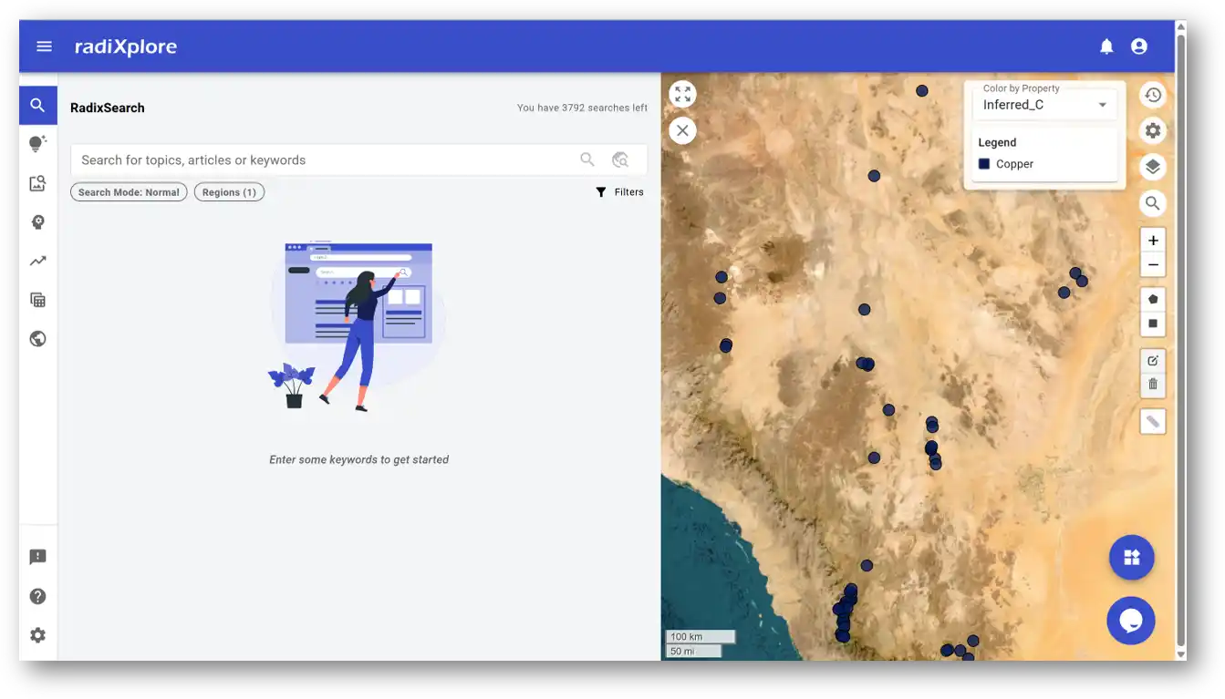
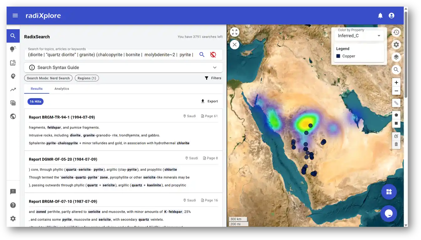
Step 1: Importing Anomaly Shapefiles
The process begins by uploading shapefiles corresponding to geochemical anomalies created in the previous blog post. In this case, we used Isolation Forest-derived outliers from stream sediment data targeting copper. Once imported, these appear as dark blue markers—each representing a statistically significant anomaly.
RadiXplore supports direct shapefile import, making it easy to align geochemical outputs with contextual datasets like geological reports.
Step 2: Describing the Porphyry Copper Mineral System with NerdSearch
Rather than using a generic “copper” search, we refined our query to focus specifically on porphyry copper systems. These deposits are particularly attractive due to their size, scalability, and relevance to long-term copper supply chains. For context on why porphyry deposits are highly sought after, see our related article:
Russell Menezes
With RadiXplore's NerdSearch, you don’t need to manually filter thousands of documents for porphyry-specific indicators. Instead, you describe the system you're looking for—e.g., "quartz veins with chalcopyrite and phyllic alteration in intrusive rocks"—and NerdSearch translates this into a structured geological search across the NGD corpus.
Want to dive deeper into how this works?
Russell Menezes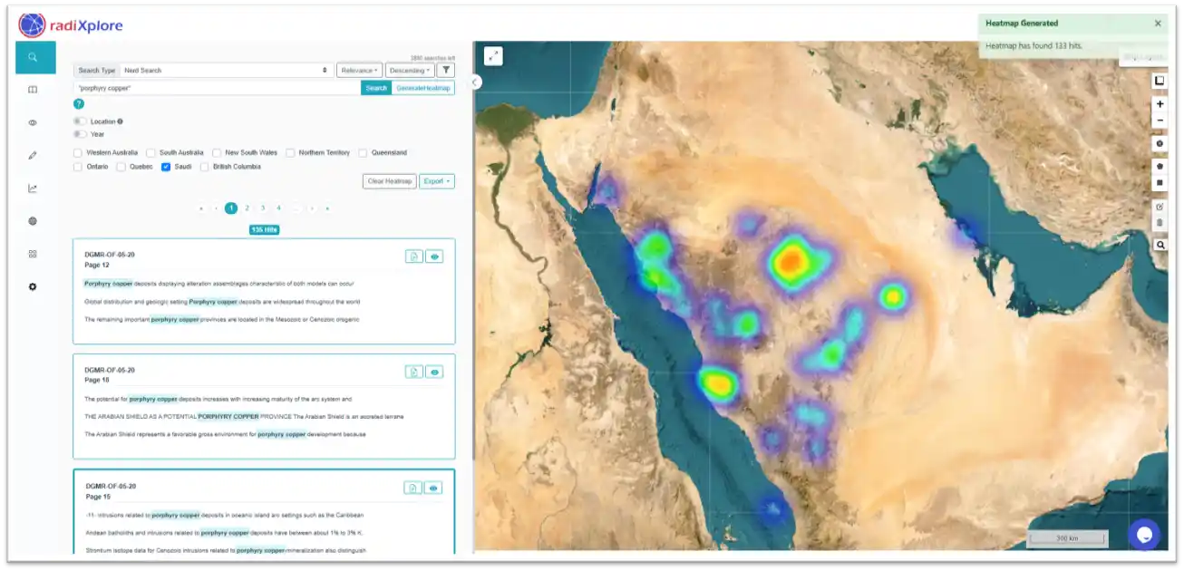
Step 3: Generating a Copper-Specific Heatmap from Textual Evidence
One of the most powerful capabilities of RadiXplore is the ability to generate geospatial heatmaps from unstructured text.
Manually building such maps from thousands of reports is nearly impossible. But RadiXplore’s preprocessing pipeline geotags every bibliographic report—typically to the quadrangle in which the fieldwork was conducted—enabling one-click heatmap generation.
The image below shows a porphyry copper-specific heatmap, created by aggregating all text evidence aligned with the defined mineral system. The map is fully dynamic; zooming in reveals more granular insights, allowing users to interactively correlate areas of textual prospectivity with AI-identified anomalies.
Step 4: Interpreting the Overlap – AI Agent Deep Dive
Visual inspection reveals areas where geochemical anomalies overlap with the literature-derived heatmap, suggesting strong convergence. To interpret these zones quickly, we used RadiXplore’s AI Agent to analyze the corresponding reports and summarize relevant findings.
Let’s look at one example:
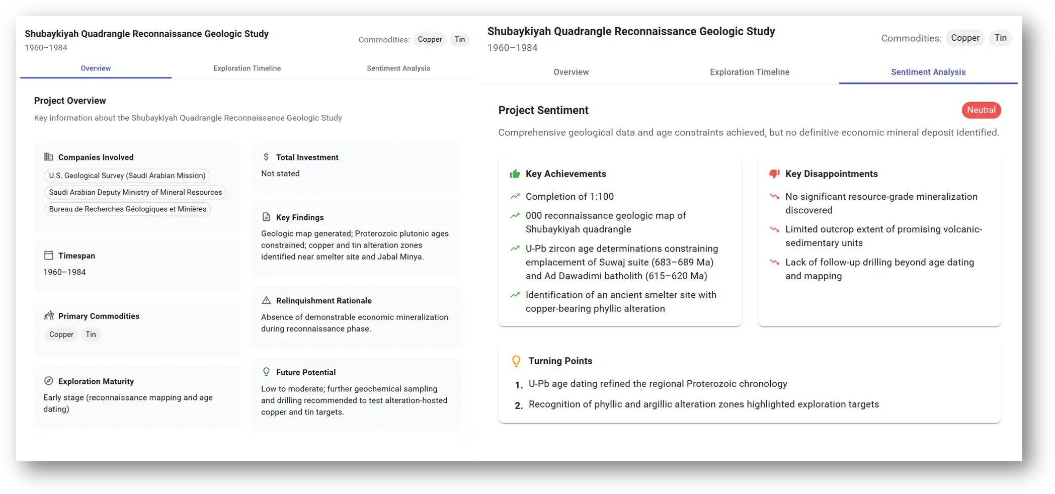
AI Agent Report Analysis
The AI Agent’s analysis of this historical report, which overlaps with both the porphyry copper heatmap and geochemical anomaly zone, offers deep geological context and significant validation for the anomaly.
Let’s break down the key findings and why they matter.
Overall Assessment
The report documents early-stage exploration—specifically, reconnaissance mapping and U-Pb age dating—conducted between 1960 and 1984. The AI Agent assigns it a "Neutral" project sentiment, noting that no economically viable mineralization was discovered at the time.
However, this doesn’t contradict the AI-detected anomaly. In fact, the context strongly supports the possibility that the porphyry system remained undiscovered or underexplored.
🔑 Key Insights
1. Exploration Maturity: Reconnaissance Stage
"Exploration maturity: Early stage (reconnaissance mapping and age dating)"
This stage of work is not meant to define deposits but to identify broad geological features. The tools and methods available at the time were limited—making it unsurprising that resource-grade mineralization was not confirmed.
2. Surface Limitations
"Limited outcrop extent of promising volcanic-sedimentary units"
This detail is critical. A lack of surface exposure can easily obscure anomalies in traditional surface-based methods. It reinforces the value of AI-powered stream sediment analysis, which can detect subtle signals even in areas with weak surface expression.
3. Lack of Follow-up Drilling
"Lack of follow-up drilling beyond age dating and mapping"
Perhaps the most important clue: this area remains largely untested below surface. No detailed geochemical programs or drill campaigns were conducted after the initial mapping—leaving the door open for discovery today.
Supporting Evidence for a Porphyry System
Copper-Related Alteration Zones Identified
"Copper and tin alteration zones identified near smelter site and Jabal Minya"
This directly links the area to known hydrothermal systems. Alteration zones are key vectors in porphyry exploration, and their presence aligns with the heatmap and anomaly.
Magmatic Timing Matches Known Porphyry Windows
"U-Pb zircon ages: Suwaj suite (683–689 Ma), Ad Dawadami batholith (515–620 Ma)"
The age constraints provided here correspond with recognized porphyry-forming magmatic episodes in the Arabian Shield—offering temporal validation for the system.
Textbook Alteration Signatures Detected
"Phyllic and argillic alteration zones highlighted exploration targets"
These are hallmark alteration styles in porphyry systems, typically forming halos around mineralized cores. Their identification strengthens the case for further testing.
Discovery of Ancient Smelter Site
"Identification of ancient smelter site with copper-bearing phyllic alteration"
This is a standout finding. The combination of historic copper use and diagnostic phyllic alteration implies a long-recognized mineralized zone—now reinterpreted through a modern mineral systems lens.
🚀 Strategic Implications for Modern Exploration
While the original report concludes that “no significant resource-grade mineralization was discovered,” this is not a contradiction to current AI findings. Instead, it suggests a classic underexplored or near-miss target—with enough evidence to warrant modern follow-up.
In fact, the “disappointments” in the report—limited outcrop, lack of drilling—become opportunities when viewed through the lens of today’s technology:
- Stream sediment anomalies may be detecting buried mineralization missed by surface reconnaissance.
- AI-driven text analysis has recovered overlooked evidence from legacy reports.
- Heatmap and anomaly overlap creates a compelling, multi-layered exploration target.
🗺️ What the Original Report Looked Like – and Why It’s So Hard to Analyze
The image below shows the actual historical report analyzed by the AI Agent—the same one that contained crucial geological clues supporting the porphyry copper anomaly.
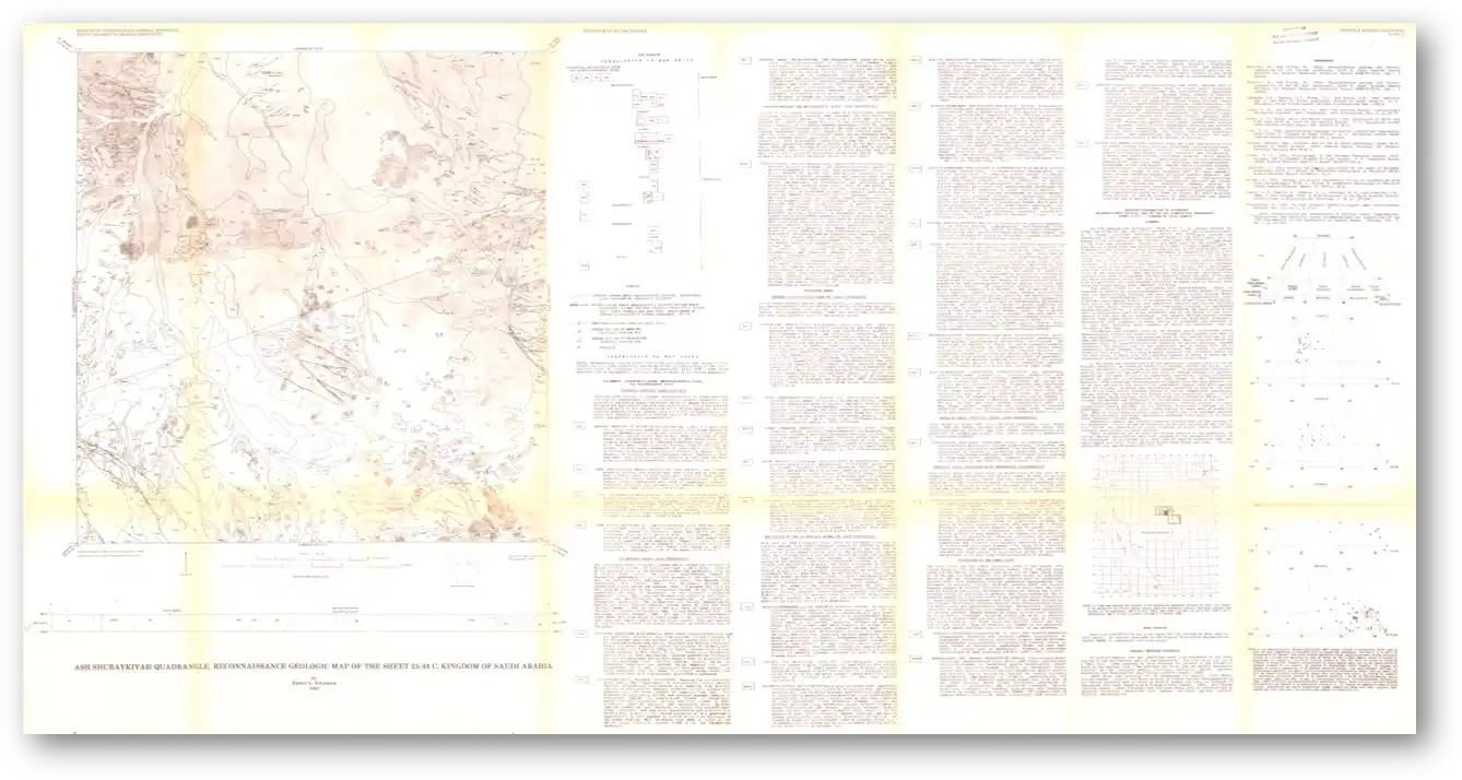
It’s a large, scanned geological map from the Shubayqiyah Quadrangle Reconnaissance Study (1960–1984), with multi-page, typewritten text physically attached beside it. The map is yellowed with age, and the accompanying text is printed in faint, tiny font—barely legible to the naked eye and even harder for OCR software to handle accurately.
This is not an exception. The National Geological Database (NGD) contains millions of pages of reports of similar quality—scanned documents with poor resolution, inconsistent formatting, handwritten annotations, and dense technical language.
Traditional tools like OCR or keyword search fail to extract meaningful insights from such documents. They struggle with:
- Poor scan quality and faded ink
- Unstructured formatting (e.g., glued notes, side columns)
- Geological jargon and legacy terminology
- Vague or implicit references to location and mineralization
Without RadiXplore, the vital information in this copper-bearing report would have remained buried and inaccessible—overlooked simply because it wasn’t machine-readable or easy to search.
Final Takeaway – And the Bigger Picture
What we’ve shown so far is just one example: a porphyry copper anomaly that aligns with historical reports, validated through RadiXplore’s AI-driven analysis. But this is not an isolated success.
We applied the same integrated workflow—combining stream sediment geochemistry, anomaly detection, and natural language processing—to anomalies associated with gold, silver, uranium, thorium, niobium, nickel, and other commodities across the Arabian Shield. In each case, the platform identified supporting geological evidence hidden deep within the bibliographic archive, often in reports that had long been forgotten or were too cumbersome to analyze manually.
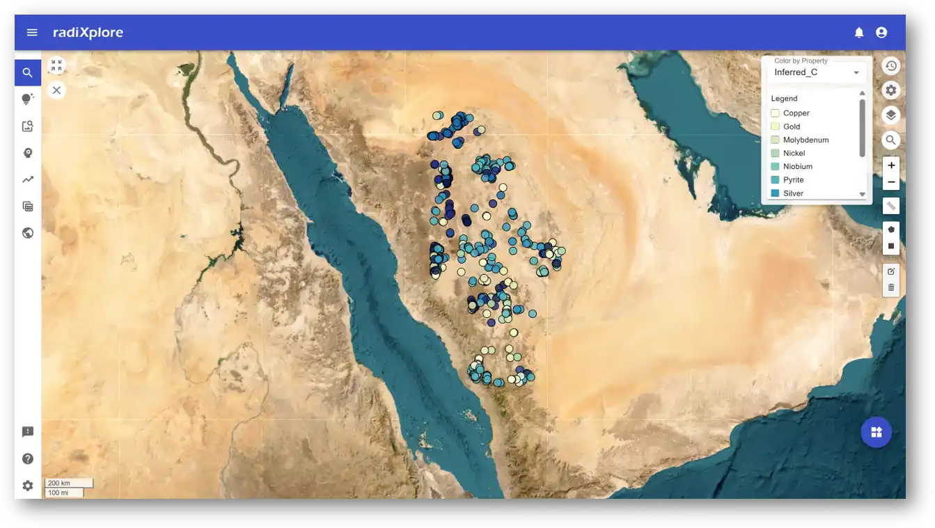
These findings suggest the presence of previously unrecognized mineral systems—not because they didn’t exist, but because no one had ever fused geochemical anomalies with the historical geological record in this way before.
RadiXplore doesn’t just process numbers. It captures and reactivates the expertise of over 100,000 geologists, whose observations, insights, and interpretations are locked inside millions of legacy reports. The platform brings that knowledge back into circulation—connecting it with structured geoscience data to drive smarter, faster project generation.
This Isn't Just About Saudi Arabia
While this case study focuses on the Arabian Shield, the underlying challenge—and opportunity—is global.
From Canada to Australia, Chile to Kazakhstan, every mature mining jurisdiction is sitting on decades of underutilized exploration reports. These datasets represent a goldmine of institutional knowledge that remains largely untapped, simply because they’re unstructured, non-digital, and hard to search. RadiXplore enables explorers around the world to systematically unlock this value and integrate it with modern exploration workflows.
Whether you’re targeting greenfield terrain or reassessing past failures, RadiXplore provides a way to merge historical context with modern signals, giving explorers a competitive edge.
A Clarification on What RadiXplore Is—and Isn’t
A common misconception we hear is that RadiXplore is "just a search tool" surfacing old opinions, not discovering anything new.
But this view overlooks the nature of discovery itself.

There is no single, magical system that will ingest all geophysical and geochemical data and instantly produce perfect drill targets. Exploration is an uncertain, interpretive process that demands geological thinking. What RadiXplore does is provide a new layer of intelligence—one that synthesizes past learnings, integrates multiple datasets, and allows geologists to spot patterns that would otherwise remain hidden.
Rather than replacing the geologist, RadiXplore amplifies their ability to make connections across data types, timescales, and disciplines.
It's not about automating judgment—it's about enabling better judgment at scale.
And in a world where billions are spent on exploration and most discoveries come from revisiting old ground, tools like RadiXplore may be exactly what the industry needs to turn missed opportunities into future mines.